Researchers build bee robot that can twist
A robotic bee that can fly fully in all directions has been developed by Washington State University researchers.
There was a shortage of entries in the tablebot competition shortly before the registration window closed for RoboGames 2023. To make sure the contest would be held, I entered a robot. Then I had to build one.
A tablebot lives on the table. There are three “phases” to the competition:
There is also an unofficial Phase IV – which is to fall off the table and survive. I did not attempt this phase.
The majority of tablebots are quite simple – a couple of sonar or IR sensors and they kind of wander around the tabletop in hopes of completing the different phases. My tablebot is decidedly different – and it paid off as the robot won the gold medal at RoboGames 2023.
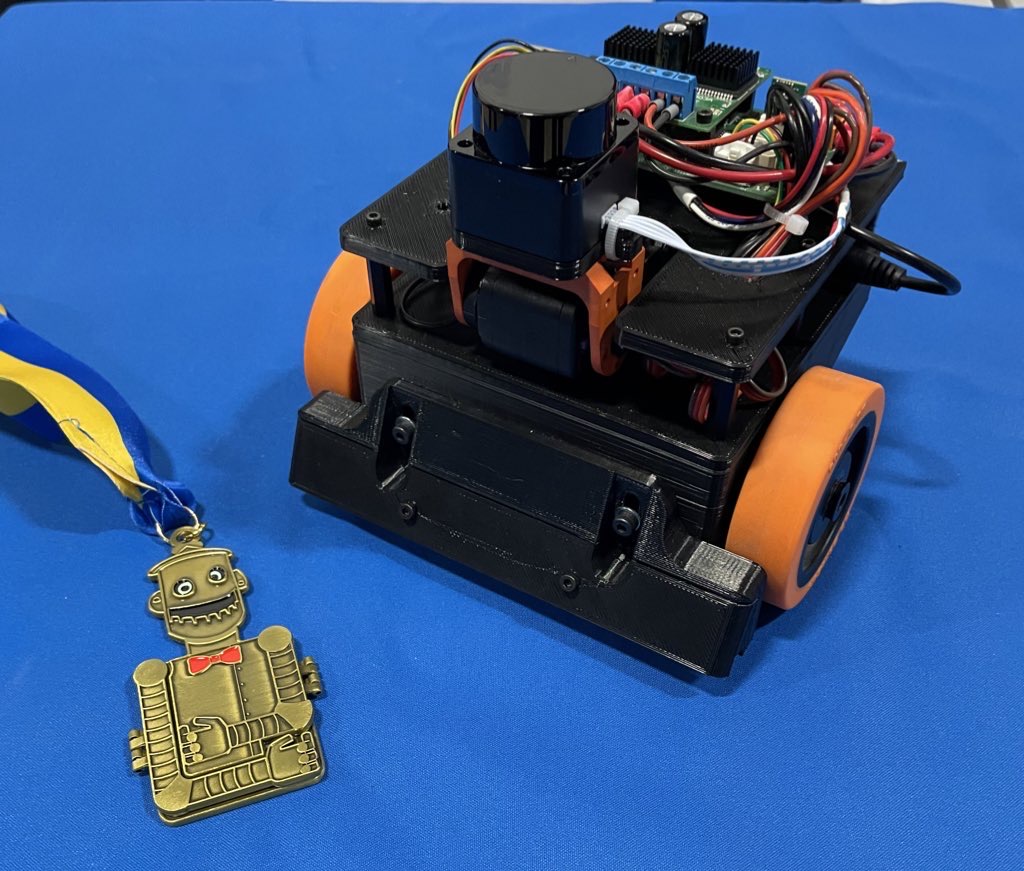
The entire robot is built of 3D printed parts and random things I had on hand.
I’ve had one of those $99 LD-06 lidars sitting around for a while, and decided this was a great project to use it on. I used a Dynamixel AX-12 servo to tilt the laser so I can find the table, the cube, or the goal.
All of the code runs on an STM32, on my custom Etherbotix board which was designed for my Maxwell robot a number of years ago. The robot uses differential drive with some 30:1 12V gear motors, which were purchased from Lynxmotion in 2008 and used in various fire fighting robots over the years.
A set of small digital Sharp IR sensors are used as cliff sensors. These can be moved up or down to calibrate for different table surfaces using a pair of adjustment screws. While the sensors are very accurate and stop the robot, they don’t see far enough ahead when going at full speed, and so I also use the laser to detect when the table edge is approaching.
Phase 1 is pretty straight forward – and mostly based on dead reckoning odometry:
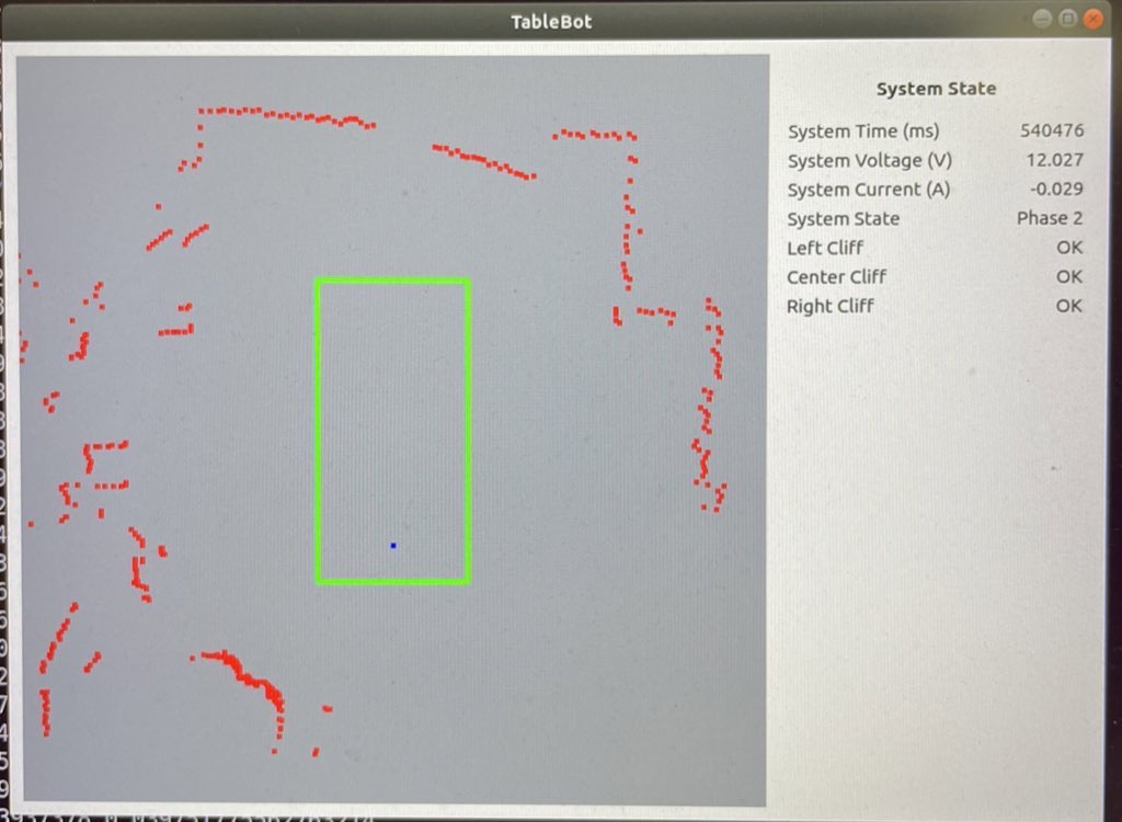
The movements of Phase 2 are basically the same as Phase 1 – we drive forward, staying centered with odometry. The speed is a bit lower than Phase 1 because the laser is also looking for the block:
The final phase is the most complex, but not by much. As with the earlier phases, the robot moves down the table finding the block:
All of the software for my Tablebot is availble on GitHub.
Jim Dinunzio, a member of the Homebrew Robotics Club, took a video during the actual competition at Robogames so you can actually see the winning set of runs:
To make development easier, I also wrote a Python GUI that renders the table, the robot odometry trail, the laser data, and detected goals and cubes.
Along the way I actually ran into a bug in the ARM CMSIS DSP library. I used the arm_sin_cos_f32() function to compute my odometry:
arm_sin_cos_f32(system_state.pose_th * 57.2958f, &sin_th, &cos_th);

system_state.pose_x += cos_th * d;

system_state.pose_y += sin_th * d;

system_state.pose_th = angle_wrap(system_state.pose_th + dth);
This function takes the angle (in degrees!) and returns the sine and cosine of the angle using a lookup table and some interesting interpolation. With the visualization of the robot path, I noticed the robot odometry would occasionally jump to the side and backwards – which made no sense.
Further investigation showed that for very small negative angles, arm_sin_cos_f32 returned huge values. I dug deeper into the code and found that there are several different versions out there:
The issue turned out to be quite simple:
With that bug fixed, odometry worked flawlessly afterwards. As it turned out, I had this same function/bug existing in some brushless motor control code at work.
It is awesome that RoboGames is back! This little robot won’t be making another appearance, but I am starting to work on a RoboMagellan robot for next year.

With technology for drones far advanced, the next step is to ensure they can fly safely in cities. Image credit: CC0 via Unsplash
The Spanish resort town of Benidorm is known for its sandy beaches with clear waters, a skyline dominated by towering hotels and tourists from northern Europe. But one day in February, it also served as a testing ground for European society’s future with drones.
Since the local economy depends on tourism during the summer, Benidorm is relatively empty in winter – and that’s a plus when it comes to safety while testing unmanned aerial vehicles (UAVs). The tall buildings that dominate the skyline also stand in nicely for those of a big city.
Sun, sea and…satellite signals
In sum, it’s an ideal place to try out new drone technology. And an EU-funded project called DELOREAN has done just that – testing new types of satellite tracking for drones on 9 February.
‘Benidorm’s skyline is quite similar to what you would find in larger cities like, say, New York,’ said Santiago Soley, the project coordinator who is also chief executive officer of Spanish aeronautics-engineering company Pildo Labs. ‘Generally, regulations limit drone flights over dense urban areas. It’s the first time in Europe we did these intense tests in a challenging city environment.’
Drones have been a hyped technology for years, during which the media popularised predictions that such aircraft would soon be used for all kinds of daily services including delivering packages to people’s doorsteps. Yet so far, widespread civilian use has failed to take off.
The bottleneck is safety and the need to demonstrate to city governments that drones can be operated in large numbers in populated areas without being a hazard. If a UAV crashes onto a busy street or into a plane that’s landing or taking off, the result could be severe damage or even deaths.
“Drone technology is getting there.”
– Santiago Soley, DELOREAN
Scientists and companies are now addressing these concerns – and the experiments in Benidorm might hold the key to the future success of drones.
‘Drone technology is getting there – it’s the least of our problems,’ said Soley. ‘What’s more important is to demonstrate how drones would safely be deployed over cities.’
DELOREAN is wrapping up after three years. The main goal was to develop navigation and positioning requirements for urban air services and show how the European Global Navigation Satellite System, or EGNSS, can help.
Non-GPS options
Drones need to know exactly where they are at all times. For that, UAVs currently rely on satellites, mostly the US Global Positioning System, or GPS. Another alternative to GPS is Europe’s Galileo network.
DELOREAN is also testing Galileo’s potential for drones.
While led by Pildo Labs, the project has featured an international consortium whose members include France-based aircraft manufacturer Airbus, Spanish postal-servicer provider Correos and the European Organisation for the Safety of Air Navigation, or Eurocontrol, in Belgium.
A challenge for satellite tracking in urban areas is that signals might be deflected or otherwise hindered by buildings. Galileo will help avoid such disruptions because of the waveform and structure of its signals, according to Soley.
In addition, Galileo is pioneering new services that could pinpoint drones’ locations with higher accuracy – something DELOREAN tested in Benidorm.
Furthermore, Galileo adds a layer of security. An authentication service that allows the drone to verify whether the satellite signal is real would counter any future efforts by criminal groups to misdirect UAVs and steal their contents through fake signals, according to Soley.
Airborne parcel deliveries
If experiments of the kinds conducted by DELOREAN prove successful, many applications could open up.
“Before businesses like urban air delivery can develop, we first need safety.”
– Professor Luis Moreno Lorente, LABYRINTH
While drones are already in use over cities, it is often in small-scale operations by local authorities. Police departments, for one, use them to monitor crowds or track speeding cars.
‘There are limitations on drone flights and you need to close the area,’ said Soley. ‘At the technical level, however, the flights are quite easy to handle.’
The next step could be mass urban air delivery. No more vans zigzagging through city streets with all the congestion and pollution.
Instead, fleets of drones would drop off packages across town. Companies like Amazon are already rolling out these services in limited areas.
‘Logistics will, I think, be one of the most promising uses of drones,’ said Soley.
Self-flying craft
An EU-funded project called LABYRINTH is tackling the challenge of ensuring that autonomous drones keep track of each other.
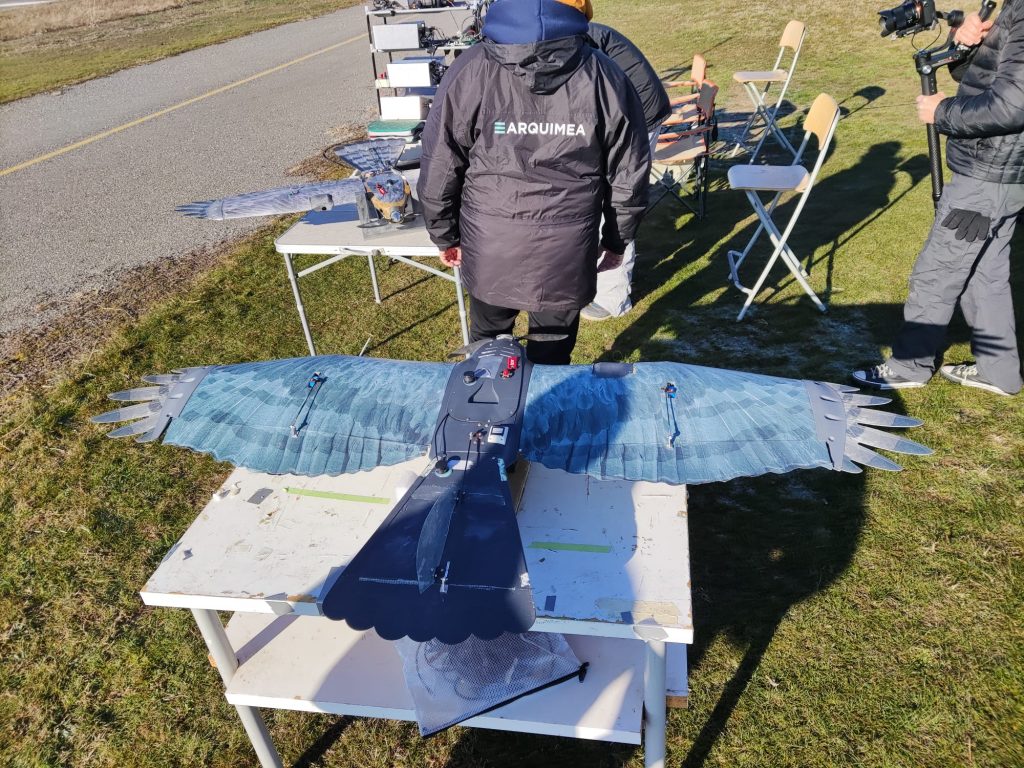
An ARQUIMEA drone being tested in Marugán, Segovia, Spain. © Labyrinth, 2023
Autonomous drones require no ground-based human pilots, who are generally needed for the current generation of UAVs.
‘In the future, those drones will be operated autonomously – they will fly themselves,’ said Luis Moreno Lorente, the project coordinator and a professor of systems engineering and automation at the University Carlos III of Madrid in Spain. ‘But if you want to do that safely, you need to know exactly where each one of them is located.’
LABYRINTH, which is due to end in May after three years, is developing software that acts as an air traffic control system for drones. The 3D position of each is tracked and the aircraft then relays this information to other drones in the vicinity so they don’t crash into each other.
Similarly, if a drone faces technical troubles – say one of its motors fails – it needs to be able to direct other UAVs away from it.
‘Before businesses like urban air delivery can develop, we first need safety,’ said Moreno Lorente. ‘That’s what we’re building now.’
Together, LABYRINTH and DELOREAN are helping to clear the way for a future in which large numbers of drones fly over cities.
‘It’s just a matter of time before they do,’ said Moreno Lorente.
Watch the video
This article was originally published in Horizon, the EU Research and Innovation magazine.

Claire chatted to Nick Hawes from the University of Oxford all about robot decision-making, long-term autonomy, and artificial intelligence.
Nick Hawes is a Professor of AI and Robotics at the University of Oxford, where he directs the Oxford Robotics Institute (ORI). Within the ORI he leads the Goal-Oriented Autonomous Long-Lived Systems (GOALS) group which researches decision-making for autonomous systems under uncertainty, including robots and human-robot teams. Recent highlights include the deployment of an autonomous mission planning stack on a quadruped at an active nuclear site, and on an autonomous underwater vehicle harvesting data from a sensor network.